
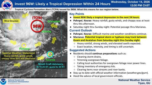
Invest 96W continues to develop and is likely to become a tropical depression within the next 24 hours, according to the National Weather Service.
As of 11:20 a.m. Wednesday, Invest 96W was located roughly 1,100 miles east-southeast of Guam and was forecast to “slowly move” northwest over the next few days.
“The Joint Typhoon Warning Center (JTWC) issued a Tropical Cyclone Formation Alert (TCFA) for Invest 96W early this morning. This means that within the next 24 hours, 96W is likely to become a tropical depression, which is a low-pressure, spinning storm system with sustained winds up to 39 mph,” NWS Guam said in a Facebook post on Oct. 14.
For residents in the Marianas, weather officials said, “The most likely time frame of passage is between Saturday night and Sunday night with an intensity anywhere between a tropical storm to a typhoon.”
NWS said the weather system could pass anywhere from Guam to Anatahan, “with model tracks between Rota and Saipan.”
“What we are uncertain about is the exact location, intensity, and timing as models continue to show many different possibilities. We advise those in the Marianas to continue preparations and stay up to date with official information from NWS Guam, JTWC, and local government and emergency management agencies,” NWS said.
Guam Homeland Security and the Office of Civil Defense said in a release that “when Invest 96W becomes a tropical depression, it will be designated 29W.”
NWS said there is potential for locally heavy rain Saturday through Monday, Oct. 17-19, with rainfall totals of up to 8 inches and localized amounts of up to 12 inches possible.
Officials also anticipate moderate trade winds through Friday, with increasing winds Saturday into Monday.
“Eventual track and intensity will dictate wind speed and direction this weekend. NWS advises preparing for at least a Category 1 typhoon. This is preparedness guidance; the system’s eventual track and intensity remain uncertain,” GHS-OCD said.
Weather officials expect seas and surf to “increase significantly Friday into the weekend as Invest 96W approaches, first from the east, then from the west as it passes the islands.”
GHS-OCD said that, as of Wednesday morning’s briefing, there was a possibility of a tropical cyclone watch being issued “as early as Thursday, Oct. 15, if needed.”
“Official track guidance will be available once the system develops into a tropical depression,” GHS-OCD said.
GHS-OCD advised residents and visitors to begin taking precautionary measures, including filling their vehicles with fuel, stocking up on nonperishable foods and filling containers with several days’ worth of drinking water.
Residents were also advised to secure homes with shutters and make sure nearby storm drains are not clogged, especially in low-lying areas.
GHS-OCD said more information will be provided in the coming days.