
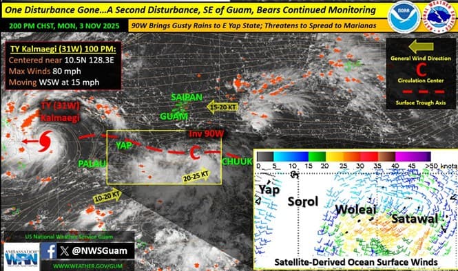
The National Weather Service (NWS) Guam reports that Typhoon Kalmaegi, previously identified as Invest 98W, has exited the region after passing north of Yap Island and intensifying to an 80-mph typhoon as it moved toward the Philippines. Its rapid departure reduced monsoon-related impacts for Yap and Palau over the weekend.
Meanwhile, a new tropical disturbance, designated Invest 90W, has developed southeast of Guam after re-emerging from a weakened system known as 99W. Satellite data indicates sustained southwest winds between 20 and 30 mph near eastern Yap and western Chuuk States. Models suggest 90W will remain mostly stationary through Tuesday before tracking west-northwest to north-northwest between Yap and Guam by midweek.
Forecasters caution that the system could bring an increase in rainfall and winds across the Marianas starting Wednesday, depending on how quickly it strengthens. “There remains considerable uncertainty in the eventual motion,” said Brandon Aydlett, Science and Operations Officer with NWS Guam, in Monday’s supplemental Regional Weather Outlook.
A Hydrologic Outlook is in effect for the Marianas, warning of potential flash flooding later this week. The NWS has also issued a Special Weather Statement for Yap and Chuuk outer islands for stronger winds and higher seas, and a Coastal Flood Advisory remains active for the Marshall Islands through Nov. 8 due to large northeast surf.