
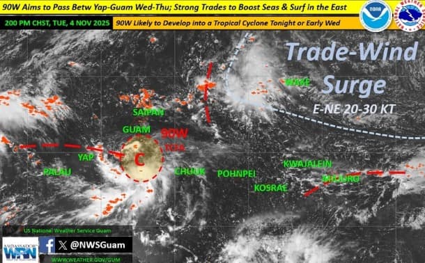
At 8:45 p.m., Tuesday, the Offices of Homeland Security and Civil Defense (GHS/OCD) urged residents to prepare for heavy rainfall, strong winds, and hazardous sea conditions as Tropical Depression 32W develops well south-southwest of Guam.
According to the National Weather Service (NWS) Guam Weather Forecast Office, TD 32W — formerly Invest 90W — was located near 9.5°N and 142.7°E, about 310 miles south-southwest of Guam as of Tuesday evening. The system is moving west at 10 mph with maximum sustained winds of 30 mph. It is expected to slow down and track near Ulithi and Fais in Yap State through Wednesday.
Forecasts call for gusty easterly winds shifting southeast, with sustained winds between 20–30 mph and gusts up to 40 mph. Heavy rainfall totaling 4–8 inches is possible through Friday, raising the risk of flooding and mudslides. The NWS has issued multiple advisories: a Flood Watch for Guam and Rota, a High Surf Advisory with surf up to 11 feet across the Marianas, a High Risk of Rip Currents, and a Small Craft Advisory for coastal waters.
Officials urge the public to clear storm drains, avoid flood-prone areas, and stay out of the water due to dangerous surf and rip currents. Drivers are reminded to slow down in heavy rain and to “Turn Around, Don’t Drown” when encountering flooded roads.
For updates, visit weather.gov/gum or follow GHS/OCD on Facebook.