
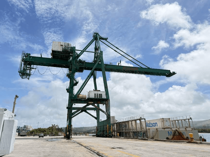
The National Weather Service Guam does not have data to confirm the 100 mph winds reported by the Port Authority of Guam when three gantry cranes were damaged Friday night, according to Warning Coordination Meteorologist Landon Aydlett.
Aydlett said official weather stations recorded peak wind gusts of roughly 61 to 63 mph, while acknowledging that a powerful squall moved through the Port around the time Gantry Crane 6 was dislodged and collided with Gantry Cranes 5 and 4.
He also said the incident highlights a potential gap in Guam's Condition of Readiness system, which is based on the onset of damaging tropical storm-force winds and the mechanism producing the weather.
On Sept. 30, NWS officials began preparing residents for risks associated with the weather event, urging them to prepare for tropical-storm-like conditions. No tropical storm watch or warning was in effect, and the Condition of Readiness system was not activated.
Aydlett said Guam experienced a multiday monsoon surge south of then-Tropical Storm Choi-Wan.
On Oct. 3, the Port said its wind gauges recorded winds of 100 mph when the gantry cranes were damaged Friday evening.
"Wind gauges on its gantry cranes recorded winds of 100 mph at the time of the incident Friday evening. Guam was not under a tropical storm watch or warning at the time, and forecasts had called for wind gusts of up to 50 mph," the Port said.
Over the weekend, Aydlett and his brother, Brandon, the meteorologist in charge at NWS Guam, toured the Port to assess the impacts.
"A lot of that wind was coming up right off Apra Harbor into the Port area, so definitely some strong impacts over there. We did not have tropical storm watches or warnings in effect at the time as we were not anticipating damaging sustained tropical storm-force winds of 39 mph or more looking at all the available weather data," Aydlett said.
At the Guam International Airport, maximum sustained winds reached 33 mph, with peak gusts of 61 mph. In southern Guam, sustained winds reached 27 mph, with gusts of 63 mph. At Andersen Air Force Base, the highest wind speed recorded was 39 mph, with peak gusts of 52 mph.
Stronger winds were recorded in Saipan on Saturday afternoon, with gusts reaching 77 mph.
"All these official measurements aligned right there with our forecast. Of note, we did have Gale Warnings in effect for Guam and Rota waters for tropical-like storm conditions," Aydlett said.
Aydlett said at this time, NWS Guam does not have data to support the 100 mph winds reported by the Port.
"We are collecting and compiling as much wind data as we can from a variety of sensors to pull the information and look at the gust and as noted we've seen those wind gusts of 63 mph across southern Guam and 61 mph here at the Guam Airport, we're also looking at the balloon ... data. What was the atmosphere doing just above the surface on Friday, Friday evening, Friday night and Saturday," Aydlett said.
He said stronger winds are typical 1,000 to 3,000 feet above the surface.
During the tour of the Port, Aydlett reviewed security footage that captured Gantry Crane 6 being dislodged and pushed down the rail system before colliding with Gantry Crane 5, which then made contact with Gantry Crane 4.
"Definitely they did have a powerful squall go through blasting through the Port right around 9:30 that evening and so that was when everything happened. ... Something major happened and the wind was a factor indeed because we did have some powerful wind squalls," Aydlett said.
Aydlett confirmed seeing a reading from one of the cranes showing an 83-mph wind gust.
"Those far exceed everything else we've seen across the region," he said.
He said the visit to the Port was important to NWS Guam.
"We definitely wanted to see things firsthand. We wanted to see the perimeter, the periphery foliage, whether there are any other impacts, limbs down, trees down, anything else impacted by 100 mph winds," Aydlett said. "Those are all part of this mystery, all part of piecing this puzzle together."
In a release Monday, Oct. 5, the Port reported that Gantry Crane 4 returned to service at 1:37 p.m. Gantry Crane 5 has been returned to the rail system but requires repairs, inspection and recertification before returning to service.
The Port also said efforts continue to return Gantry Crane 6 to the rail system.
"Once realigned, technical assessments will continue to determine the repairs necessary for its safe return to service. The Port is also moving forward with emergency procurement through Governor Lou Leon Guerrero's authority, for the rental, mobilization, operation and related services of a temporary mobile crane, commonly referred to as a 'stick crane,' to assist with vessel operations," the Port said.
The response efforts include inspections and technical assessments to determine what effect, if any, the weather event had on the "remaining service lives of Gantries 5 and 6."
"Gantry Crane 6 had been locked in position and secured based on the guidance in place at the time. The Port's crane wind gauges recorded winds of approximately 100 mph during the incident. The Port has not characterized the incident as either a procedural failure or mechanical malfunction as the technical assessment remains ongoing. The recorded wind speed provides context regarding the conditions experienced by the cranes as the Port works to determine exactly how Gantry 6 became dislodged," the Port said.
Aydlett stressed that although the Condition of Readiness system was not activated, that did not mean Guam was in the total clear.
The weather event exposed a gap in Guam's overall readiness for non-cyclone events. Adylett said the Condition of Readiness system is established based on the onset of damaging tropical storm-force winds, rather than the intensity of the weather system.
"The question is what's the difference between a 40-mph monsoon and a 40-mph tropical storm? As far as impacts, there is no difference, but as far as what's causing it, the mechanism, that's the difference," Aydlett said.
Aydlett highlighted that the COR system initiates government pre-storm readiness measures on a large scale but other weather events like the recent monsoon without a COR system activation run on a smaller scale.
"I think this is where there's room for some modifications that focus on those impacts versus just the mechanism for the weather conditions."
Aydlett said making any changes would require discussions and "a diligent process."
"There's a lot of moving parts. The CORs process flows through the veins of Guam, for better or for worse. The Condition of Readiness between Guam and the CNMI, they're different. The CNMI delineates tropical storm versus typhoon for their conditions, whereas the Government of Guam, this used to be the case ... years ago but then that was changed," Aydlett said.
He said any change would require discussions involving the governor's office, the Legislature, Guam Homeland Security and federal partners.
"It affects everybody and the COR itself is a great system, it's a posture system but we need to make sure that system encompasses all other weather hazards that have similar impacts to tropical cyclones," Aydlett said.